One of the PhD research project conducted through EENSAT project aimed at understanding the spatiotemporal dynamics of crop phenology and crop yield in Lake Tana Basin. For this research, the EENSAT project provided three field instruments, namely: Atmos 41 all in one weather station together with PAR sensor, four Dorr SnapShot wild cameras and one AccuPAR ceptometer. The instruments provided a valuable opportunity for technology transfer to Bahir Dar University for future research works.
The Decagon's AccuPAR model LP-80 PAR/LAI Ceptometer, which is one of the field instruments provided, measures light interception in plant canopies and converting that PAR value into Leaf Area Index (LAI). It measures PAR ranges from 0 to 2,500 µmol m-2s-1. AccuPAR has a calibrated external PAR sensor that it uses for making simultaneous above and below canopy PAR measurement. The LAI measurements taken by the AccuPAR will be used to:
- estimate the major phonological stages from remote sensing data,
- assimilate in to crop yield model, and
- identify crop growth stages with high correlation with yield.
The study and data collection is conducted in Lake Tana sub-basin, Ethiopia for maize, rice and teff crops.
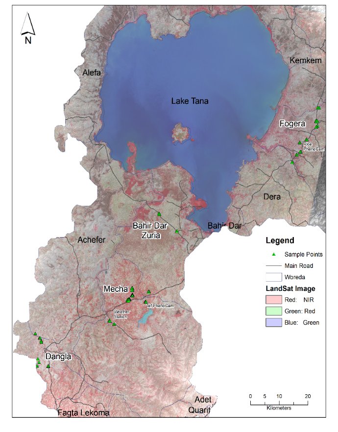
Figure 1. Sample site
Sampling protocol
To collect PAR and LAI data for maize, rice and teff crops, four Woderdas namely Bahir Dar Zuria, Fogera, Mecha and Dangla were selected considering topographic, climate and agroecological factors. Collecting spatially representative and accurate LAI data is vital to calibrate and validate remote sensing based crop phenology and to model crop yield in the study area. Therefore, 16 maize fields, 15 rice fields and 11 teff fields were identified using multistage the stratified sampling technique. LAI readings were taken during the early vegetative stage, peak vegetative and reproductive stages of the three target crops. Due to farmland fragmentation, mixed cropping pattern, and to consider geolocation error while matching the sample value with satellite data, the sample plots are at least 60m2. For each sampling field ten transect quadrants are flagged to make AccuPAR readings.
The hardware setup
The main components of AccuPAR ceptometer include, AccuPAR model LP-90 light bar, external PAR sensor attached with cable, RS-232 Cable and LP-80 utility software. In addition, camera tripod with mounting fixture is needed for leveling of the external sensor in the field. The external PAR meter needs to be mounted on the tripod or pole and cable connected with the AccuPAR. Once the external PAR is attached, the instrument is ready to start and measure above and below canopy PAR readings.
Input parameters and calibration
For the AccuPAR ceptometer to calculate LAI, it is important to enter all the information required accurately depending on the location of the sample field and crop type. The zenith angle, fraction of beam radiation, and the leaf angle distribution are required by AccuPAR to calculate LAI.
Location
Zenith angle and fraction of beam radiation will be automatically calculated when setting geographic location of the sample sites and setting the local time. Latitude and longitude are rounded to one degree place. Hence, 370E & 110 N for Mecha and Dangla and 380E & 120N for Fogera and 370E and 110 N for Bahir Dar samples were used in this study.
Leaf distribution parameter (χ)
Perhaps the most difficult parameter to determine is the χ. It describes how leaves are oriented in space and describes how light is intercepted by the leaves. To estimate the value for target crop types (maize, rice and teff), the percentage vertical and horizontal gap fraction were considered. First, representative clump of canopy of equal depth and width were identified. Then a white sheet of paper on the ground between two representative crop rows was placed and the percentage of light to shadow by looking down (for instance 60% at the early vegetative stages of maize growth) was estimated. Second, to repeat the process, by placing the paper behind the two rows and estimate the percentage of light to shadow looking across (70%). Finally, calculate χ value by dividing ln of vertical gap to ln of horizontal gap fraction (for instance 1.43 for early stage of maize growth).
In addition, the AccuPAR should be calibrated at each stage of crop development or data collection period and location. Calibrating the AccuPAR’s probe, ensuring that the PAR response between the external sensor and the probe are the same. To calibrate the PAR level must be above 600µmols m-1 s-1 a value in a clear sky.
Taking field measurement
To make AccuPAR readings, sample field preparations were necessary such as to flag ten 1m2 quadrant, remove non-targeted plants, and avoid grazed areas, edge of the plot and areas directly adjacent to past sampling. Ten below and above canopy sample readings were taken and the average of these recorded as the quadrants value. To get a reliable measurement by the AccuPAR, it is also important to properly place the ceptometer between the rows to get representative values (Figure 2). Leveling the light bar and external sensor, re-calibrating the light bar when sky conditions frequently change, placing the instrument completely bellow the canopy are some of the important considerations to get accurate results. The readings were saved for every quadrant in a code that matches the GPS reading, unique for the crop types and location. Until preparing this news item, we have been able to collect 100 observations.
Challenges
Instrument design: Installing an external sensor on a tripod makes farmers suspicious about the objective of my field measurement due to land tenure security problems in Ethiopia. Since the instrument is sensitive it comes with a big case which is cumbersome to carry to the field and creates security concerns. My supervisors advised me to use a stick for the external sensor. I also prepared a box protecting the sensitive part (wand) and carry it with a field bag. Both solutions were successful.
Small data collection window: To get good result, the time window for field measurements is ± 2 hours of solar noon. On the other hand, the sample fields are spread in different locations, making it difficult to cover all samples within the satellite overpass period.
Measurement errors. Sometimes the sky condition frequently changes and I forgot to calibrate the instrument and when looking back the data, I found it doesn’t look representative and I was forced to re-do. On some fields, especially for maize I was unable to perfectly follow the same direction of transect for first, second and third observation in the same field. This resulted in a mismatch of the 10 sample plots. I was able to edit following my GPS track.
Fragmentation and small size of farmland: The cropping pattern in the study area is fragmented particular for teff crop. The size of a farmer's plot is also below 1ha. Consequently it was challenging to get sample fields satisfying the intended size for remote sensing application.
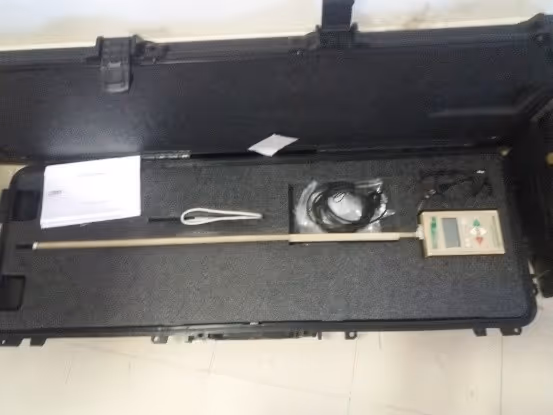
Figure 2a. The AccuPAR ceptometer
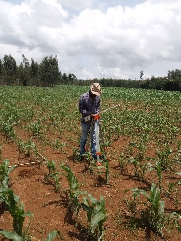
Figure 2b. Instrument setup at the field
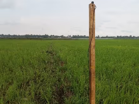
Figure 2c. External sensor mounted on stick
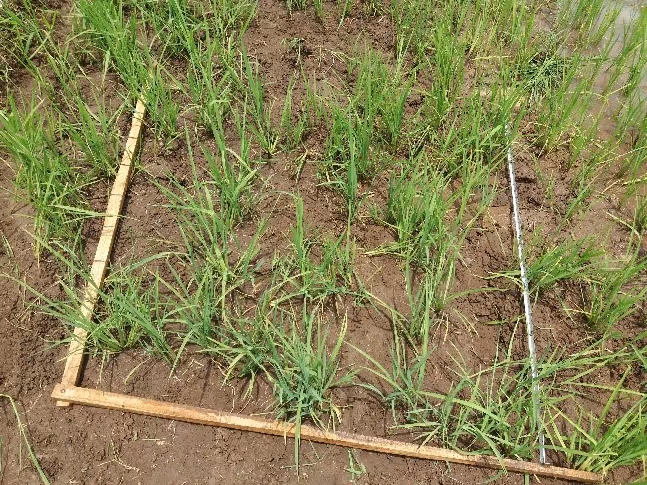
Figure 2d. Field preparation
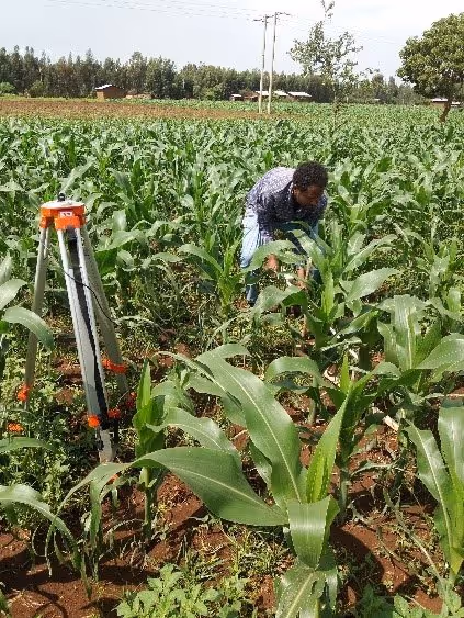
Figure 2e. Taking measurements
More recent news
 Tue 18 May 2021Training of trainers of TVET and Development Agents by BDU continues
 Tue 27 Apr 2021Successful Training of Trainer approach implemented at Bahir Dar TVET
 Thu 15 Apr 2021Tigray Bureau of Water Resources and Tigray Bureau of Health trained
 Thu 1 Apr 2021Development Agents trained at BDU on GIS for Natural Resource Management
 Thu 18 Mar 2021EENSAT features at MoSHE event